The McMahon-Shatra Line
Chinese Warlord Zhao Erhfeng's campaigns in Kham (particularly in the Pome and Zayul areas) between 1905 and 1911 brought the Chinese close to the Indo-Tibet border in the North-East.

Introduction
Chinese Warlord Zhao Erhfeng’s campaigns in Kham (particularly in the Pome and Zayul areas) between 1905 and 1911 brought the Chinese close to the Indo-Tibet border in the North-East.
In Zayul, the Chinese issued an order to the Chief of the Mijir Mishmis to open a track from Tibet to Assam. They also sent an expedition on the Delei river and planted their dragon flag at Menilkrai on the Lohit (South of Walong) with the inscription ‘The Southern Frontier of Zayul on the Borders of Sichuan Province of the Chinese Empire’.
This raised alarm bells in London; the British also realised that the treaties signed with China and Russia regarding Tibet (in 1906 and 1907 respectively), had no relevance if they could not be implemented on the ground.
It is in these circumstances that London decided to call China and Tibet for a tripartite Convention to solve the Tibetan problem, secure a buffer zone between British India and China, fix the Indo-Tibet boundary and ensure peace and stability in the region. Simla was selected as the venue for the Tibet Conference (1913-14).
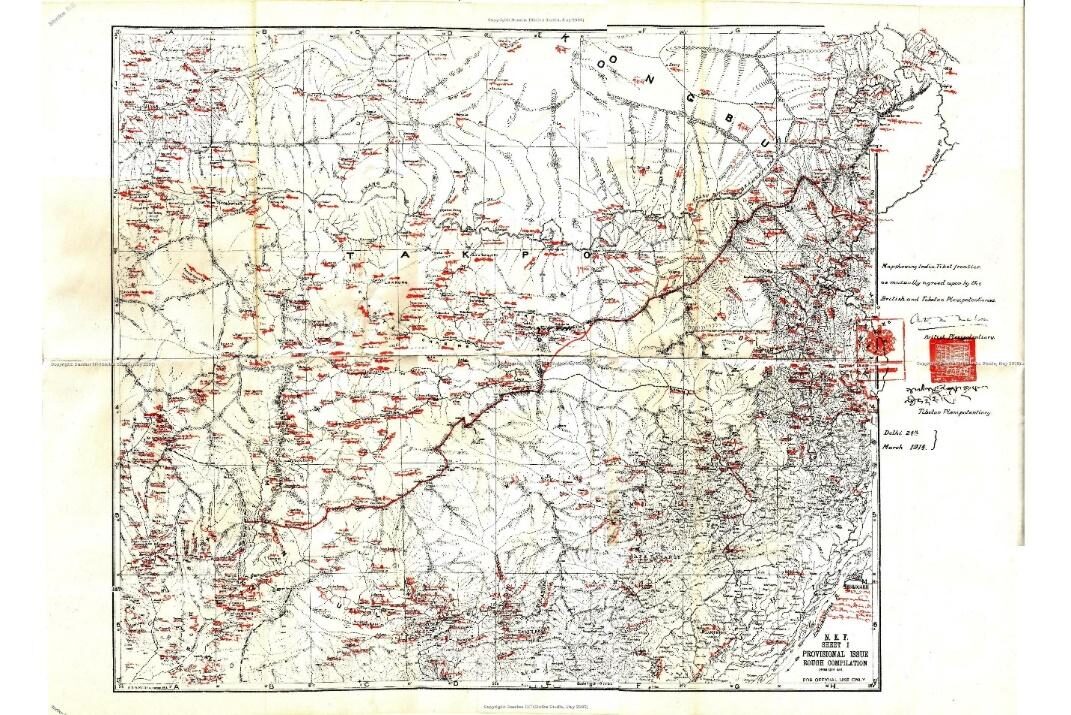
When we speak of the border between India and Tibet in the North-East, it is common to call the demarcation of the boundary—drawn on two paper sheets in March 1914—the ‘McMahon Line’.
In our views, it should be called the McMahon-Shatra Line since the maps agreed upon by the governments of India and Tibet, carried two signatures and two seals (that of Sir Henry McMahon, the British Plenipotentiary and his Tibetan counterpart, Lonchen Shatra Paljor Dorje, the Tibetan prime minister).
Both signatories represented their respective countries at the Tibet Conference (some authors referred this conference to as the Simla Conference).
Who were the British and Tibetan Plenipotentiaries?
Arthur Henry McMahon
Lt Col Sir Arthur Henry McMahon (1862-1949) was a British Diplomat and an Army officer. In 1914, he was Foreign Secretary to the Government of India; later he served as the High Commissioner in Egypt from 1915 to 1917. In Simla, McMahon was assisted by Charles Bell, the 13th Dalai Lama’s old acquaintance from his Kalimpong days.
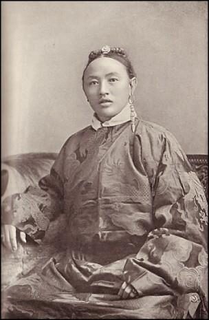
Lonchen Shatra Paljor Dorje
Lonchen Shatra, after marrying into an aristocratic family in Lhasa, the Shatra, used ‘Shatra’ as his name, as it was then the custom in Tibet. When the Dalai Lama returned to Lhasa after his exile in India (1910–1912), Shatra won the pontiff’s confidence. In October 1913, Shatra was nominated as Plenipotentiary to the Tibet Conference. He was known as a progressive official and a supporter of reform in Tibet.
Sir Charles Bell wrote: “[Shatra showed skills and a political power that surprised many at the Conference. His simple dignity and charming way of doing things made him beloved by all who knew him in Simla and Delhi.” India’s north-eastern border with Tibet certainly owes a lot to Lonchen Shatra.
The Background
In 1913, war in Europe appeared imminent; the British finally realised that the treaties regarding Tibet, signed with China and Russia (in 1906 and 1907 respectively), had no relevance as they could not be implemented in practice. In these circumstances, London decided to call China and Tibet for a tripartite Convention to solve the Tibetan problem, secure a buffer zone between British India and China, and ensure peace and stability in the region. Simla was selected as the venue for the Tibet Conference, and Sir Henry McMahon was to chair the tripartite talks. It must be noted that 10 years earlier, Lord Curzon had already thought of Simla as the place for such a Conference.
It was not an easy proposal; for months the Chinese were rather reluctant to sit at the negotiating table on an equal footing with the Tibetans. But diverse factors forced them to agree; the Chinese were aware that the Dalai Lama was close to some British officers such as Charles Bell, and they feared another Lhasa-like Convention (of 1904) in which they would perhaps not even be asked to participate.
More importantly, the military situation in Kham was not favourable to the Chinese as most of the territory captured by Zhao Erfeng had been recovered by the Tibetan troops. The Tibetan army was now better organised, and was armed with imported weaponry. Following the Dalai Lama’s return, the Tibetan army underwent British-style-training. According to all records, it was the clinching factor.
This development was worrisome for the Chinese who were already apprehensive after Mongolia signed a Treaty with Tibet, in 1913, under Russian influence. For the Chinese, the question was: Would the Tibetans join the British sphere if they refused to participate in the Conference? Hence, the Chinese felt they had no alternative but to accept the British conditions and attend the proceedings in Simla.
The 13th Dalai Lama chose Lonchen Shatra, his experienced Prime Minister, as his representative; he had dared to suggest negotiations with the Younghusband Mission 10 years earlier. Trimon, Bell’s assistant, had prepared detailed documentation on the legal status of Tibet, especially of the eastern border areas.
It was certainly one of the great surprises of the conference: the Tibetans had come well prepared with volumes and volumes of original documents, while the Chinese had no documents to prove their claims.
The brief given to Lonchen Shatra by the Dalai Lama was clear:
- Tibet was to look after its own internal affairs;
- Its foreign affairs were to be managed for important matters in consultation with the British;
- No Chinese Amban or official should be posted in Tibet;
- Tibetan territory should include all the Tibetan-speaking areas up to Dartsedo in the east and Kokonor in the north-east.
When the Conference assembled, it became immediately apparent that the positions of the Tibetan and Chinese delegates were diametrically opposite on the Tibet-China border.
In his presentation, Lonchen Shatra reiterated the Dalai Lama’s viewpoints, and formally requested recognition of Tibet’s independence. He also wanted the Dalai Lama to be acknowledged as the temporal and spiritual leader of Tibet. He claimed that the Tibetan territory should include all the Tibetan-speaking areas of Kham and Amdo. Lonchen Shatra also requested that the Conference declare the Conventions of 1906 (with China) and 1908 (with Russia) invalid, as Tibet had not been a party to them.
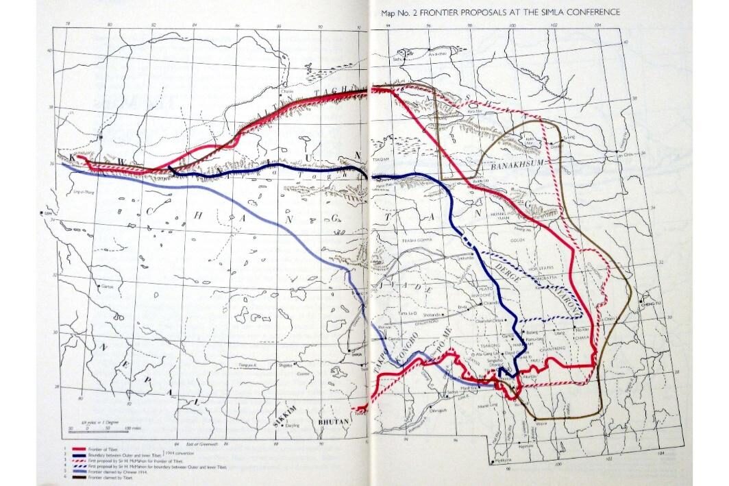
The Chinese stand however, was very different. Ivan Chen claimed Tibet as a part of China. He explained that after the conquest of Genghis Khan, Tibet had become a part of the Chinese Empire. Another argument that he used was that the Tibetans had called upon the Manchus for military assistance many times, and each time the Emperor had come to provide support. He gave the examples of the invasions of the Dzungar people of Mongol in the 18th century and the Gurkhas in the 19th century.
For the Chinese, the status of Tibet had to be restored as per the 1906 Agreement, and the border between China and Tibet was to be in Gyamda, some 150 miles east of Lhasa.
The Chinese and Tibetan perception of the location of the Sino-Tibet border was extremely different (see Figure 2). The British Plenipotentiary was caught between two opposing viewpoints, and on behalf of His Majesty’s government, McMahon had to harmonise the two sides.
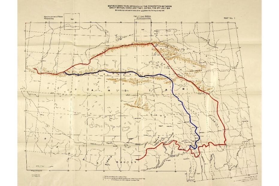
He found a way out by dividing Tibet into two parts, with consequences that are still felt today. McMahon believed that he could impose a ‘fair deal’ on both parties that would also be advantageous for Great Britain. Accordingly, Tibet was to be divided into two parts:
- ‘Outer Tibet’ which corresponded roughly to Central and Western Tibet including the sections skirting the Indian frontier, Lhasa, Shigatse, Chamdo; and
- ‘Inner Tibet’ including Amdo Province and part of Kham.
‘Outer Tibet’ was to be recognised as autonomous. China would not interfere in the administration of Outer Tibet, nor with the selection of the Dalai Lama. No troops or Ambans would be stationed there. It would not be converted into a Chinese Province.
The Need to Settle the Indo-Tibet Boundary
Soon after the Conference started, the British felt the need to separately demarcate their border with Tibet; the Chinese Plenipotentiary would not be involved in the entire process.
On 21 November 1913, Lord Hardinge, the Viceroy, sent a proposal for the Indo-Tibet boundary: “They are based on recent survey and information obtained of limits of effective occupation and territorial rights on either side.”
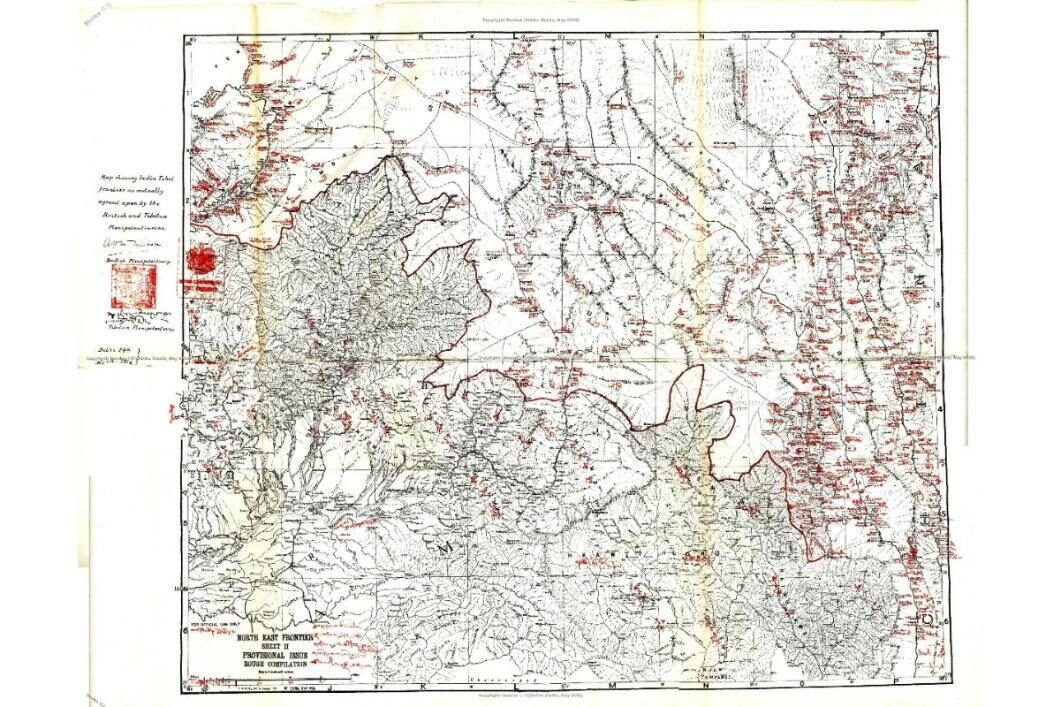
One must admit that the knowledge of the border was rather vague, but McMahon was anxious to open a discussion with Lonchen Shatra pending settlement of more difficult questions. The Viceroy referred to a map in two sheets showing the north-east frontier map, sent by the Foreign Secretary on 02 October 1913.
Starting from near Isu Razi Pass [in Burma on Salwin divide line follows throughout main northern watershed of drainage into the Irrawaddy and Brahmaputra basins as far as peak 16,834 on Tsangpo-Dihang divide [East of Pemakoe, except at one place near the Burma border (the Taron river area).
Isu Razi was the border pass between Yunnan province and Burma (now Myanmar).
The same day, Sir T.W. Holderness, Under Secretary of State for India, recommended some special consideration for the frontier in the Lohit valley:
(1) it is perhaps the most vulnerable point between Isu Razi and Chumbi (Sikkim), and (2) the Chinese have advanced definite claims there by creating flags at Menilkrai purporting to mark the boundary line. …His Majesty’s Government are under no obligation to accept an ex-part definition of the border; and in any case the situation has been entirely changed since January 1912 by the expulsion of the Chinese from Zayul, which has deprived them of all power to enforce their claim to the Menilkrai line.
It must be pointed out that Menilkrai (Walong) is far north from the line claimed by China today.
The same memo concluded:
West of the Lohit region, the proposed frontier seems generally suitable. The recent surveys in the Abor country (i.e. the valleys of the Dihang and Dibong rivers and their various affluents) have made it possible to define with some degree of precision the line of division between tribal and Tibetan influence; and it is on this division that the Government of India’s proposals are based.
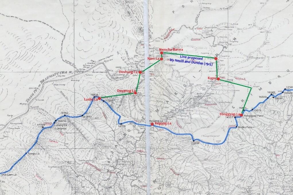
The Vice-Roy had commented: Westward from peak 16,834 [Lushe La on the Tsang Po-Dihang divide our information does not yet suffice to permit of detailed definition.
What is not mentioned is that different proposals had been made a few months earlier by the General Staff in London. They were based on earlier tours of administrators/explorers like Captains Neville, Morshead, Bailey, or Dundas. In the Pemakoe area, the border was drawn over the Namcha Barwa leaving the area with India. It was rejected by the British government as a gesture of accommodation towards the Tibetan views, who argued that the area was mainly inhabited by Tibetans. Similarly, in Tsari sector, the Dakpa Shelri was included in the first draft of the line but later given to Tibet in view of the religious importance of the Tsari Yatra (known as Rongkor).
About the Tsari sector, the Vice-Roy observed:
We do not know source of Subansiri, nor the southern limits of Tibetan possessions in and south of Tawang. The line can only be defined in general terms as running in general south-westerly direction along mountain range which forms main northern watershed of rivers draining so southward into the Brahmaputra basin until it reaches limit(s) of Tibetan district of Tawang, and thence following southern limits of Tawang to Bhutan. …Until we obtain further information this line may be roughly marked on map along chain of peaks.
The least one can say is that it was not very precise. The line drawn by the British survey was often following the higher peaks, more information was required for a watershed line which could differ from the peaks’ line.
It explains why two young captains, Frederick Bailey (intelligence) and Henry Morshead (survey), were sent on an expedition to clarify many unclear locations on the maps.
Finally, the Indo-Tibet border agreement was signed on 24 March 1914.
After the signature of the bilateral agreement, Bell told McMahon:
I told the Lonchen [Shatra that the boundary line which I had shown him was …based on the reports of British Officers and surveyors, who had made careful surveys …and the proposed line appeared to represent an equitable frontier between Tibet and India.
Bell further stated:
The Lonchen recognised the friendly attitude of the British Government towards Tibet. He stated that for the purposes of the present Treaty he accepted the proposed boundary line. …His only request was that [if any territory belonging to Lopas [local tribes under Lhasa had been included within the land on the British side of the line, questions might be settled direct by the Tibetan Government with the British Government.
This was accepted by the British government.
For the rest of the boundary, the Viceroy also wrote:
In view of possible dispute as to the correct boundary between Tibet and Bhutan and Nepal, we think it is preferable to confine Indo-Tibet boundary laid down by Agreement map to Assam-Tibet boundary East of Bhutan and the north-East-east salient of Burma.
Retrospectively, one can regret that the entire border was not demarcated on a map at that time.
Some Conclusions
- In 1913-14, India and Tibet were on friendly terms, it was therefore enough for them to have a rough line marked on a map. Clearly, each party was ready to renegotiate some parts or adjust the line if necessary. With the arrival of a new neighbour on the scene at the end of the 1950s, things took a dramatic turn.
- The Chinese were not invited to discuss the question of the border between India and Tibet, and their acceptance of the McMahon-Shatra Line was never sought; nor did they ask anything about the final demarcation. However, it was not a ‘secret’ negotiation as alleged by the Chinese today.
- Through an exchange of notes between the British and Tibetan Plenipotentiaries, the Indo-Tibet frontier was fixed in March 1914. These letters would have important consequences for the future of both nations, especially India which, 48 years later, would fight a war along the McMahon-Shatra Line.
- The boundary line was born in the form of a fat red line on a map showing the Indo-Tibetan border in the north-eastern sector. The British and the Tibetan delegates signed and put their seals on the map; it should therefore be called the McMahon-Shatra Line.